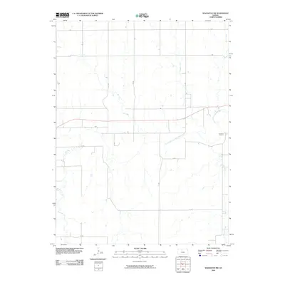
2009 Map of Woodston NW
USGS Topo · Published 2009About this map
The South Fork Solomon River defines the lower-middle corridor of this landscape in Rooks County, following a winding eastward course that anchors the local topography. This early 21st-century survey illustrates a strictly organized section-line road network, where routes such as I Rd and J Rd segment the prairie into a grid typical of the Kansas High Plains. On the eastern edge, the Woodston Cemetery serves as a significant landmark for those researching family history in the vicinity of the neighboring township. This region is a study in riparian hydrology, with several drainages including Jim Creek, Elm Creek, and Medicine Creek feeding into the main river valley. The map documents a landscape primarily shaped by agriculture and water management, captured before recent shifts in rural infrastructure.
Find a feature on this map
24 named features on this map. Tap any name to fly to it.
Don’t see what you’re looking for? This feature index may not catch every label — zoom into the map to look around manually.
Map Details
Editions of this 2009 Woodston NW Map
This is the sole edition of this map. No revisions or reprints were ever made.
Other maps of this area

1893 · Phillipsburg
USGS Topo · 1:125,000

1896 · Plainville
USGS Topo · 1:125,000

1953 · Woodston NW
USGS Topo · 1:24,000

1953 · Stockton
USGS Topo · 1:24,000

1953 · Woodston
USGS Topo · 1:24,000

1955 · Beloit
USGS Topo · 1:250,000

1959 · Beloit
USGS Topo · 1:250,000

1961 · Kirwin SE
USGS Topo · 1:24,000

1961 · Kirwin SW
USGS Topo · 1:24,000
1972 · Glade SE
USGS Topo · 1:24,000