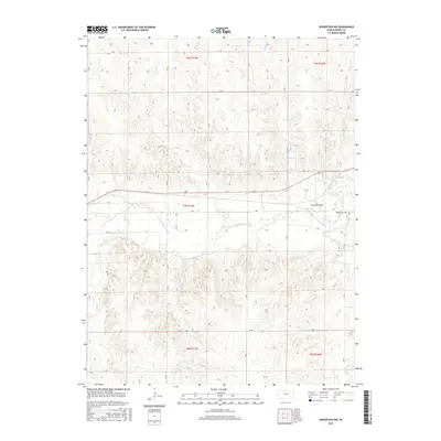
2015 Map of Woodston NW
USGS Topo · Published 2015About this map
The S Fork Solomon River defines the central topography of this Rooks County landscape, cutting a wide valley through the high plains of north-central Kansas. Near the eastern edge of the quadrangle, the Woodston Cem stands on higher ground overlooking the river valley, providing a significant point of reference for genealogists and local historians. The surrounding terrain is dissected by numerous drainage systems, including Medicine Cr to the southeast and a network of northern tributaries such as Douglas Cr and Jim Cr. A grid of section roads and terraces, including I Ter and J Ter, reveals the organized agricultural character of the region. This 2015 survey illustrates how the watercourses, particularly the Elm Cr and Buros Cr, continue to dictate the placement of rural infrastructure and land use across the townships of t7s r17w and t7s r16w.
Find a feature on this map
23 named features on this map. Tap any name to fly to it.
Don’t see what you’re looking for? This feature index may not catch every label — zoom into the map to look around manually.
Map Details
Editions of this 2015 Woodston NW Map
This is the sole edition of this map. No revisions or reprints were ever made.
Other maps of this area

1893 · Phillipsburg
USGS Topo · 1:125,000

1896 · Plainville
USGS Topo · 1:125,000

1953 · Woodston NW
USGS Topo · 1:24,000

1953 · Stockton
USGS Topo · 1:24,000

1953 · Woodston
USGS Topo · 1:24,000

1955 · Beloit
USGS Topo · 1:250,000

1959 · Beloit
USGS Topo · 1:250,000

1961 · Kirwin SE
USGS Topo · 1:24,000

1961 · Kirwin SW
USGS Topo · 1:24,000
1972 · Glade SE
USGS Topo · 1:24,000