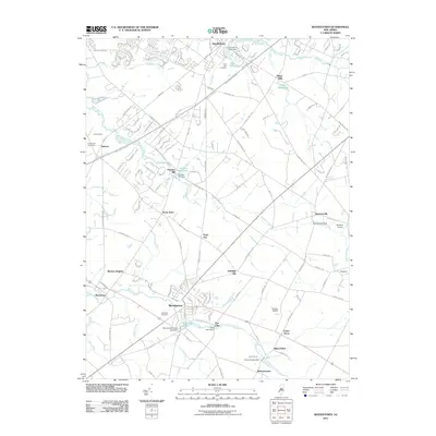
2011 Map of Woodstown
USGS Topo · Published 2011About this map
Woodstown and Swedesboro anchor this 2011 survey of Salem County, a landscape defined by the winding paths of the Salem River and Raccoon Creek. The area retains much of its historic character through small crossroads settlements like Point Airy, Seven Stars, and Harrisonville. Local industry and heritage are evident at Porches Mill on the Porches Mill Pond, while genealogy interests are served by several prominent burial grounds, including Lawnside Cemetery and Lake Park Cemetery.
Find a feature on this map
149 named features on this map. Tap any name to fly to it.
Don’t see what you’re looking for? This feature index may not catch every label — zoom into the map to look around manually.
Map Details
Editions of this 2011 Woodstown Map
This is the sole edition of this map. No revisions or reprints were ever made.
Other maps of this area

1890 · Salem
USGS Topo · 1:62,500

1890 · Glassboro
USGS Topo · 1:62,500

1891 · Philadelphia
USGS Topo · 1:62,500

1894 · Chester
USGS Topo · 1:62,500

1894 · Philadelphia
USGS Topo · 1:62,500

1896 · Philadelphia
USGS Topo · 1:62,500

1896 · Chester
USGS Topo · 1:62,500

1898 · Salem
USGS Topo · 1:62,500
1898 · Glassboro
USGS Topo · 1:62,500

1898 · Chester
USGS Topo · 1:62,500