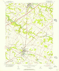
1955 Map of Woodstown
USGS Topo · Published 1956About this map
The Pennsylvania-Reading Seashore Lines cuts a diagonal path through this corner of New Jersey, anchoring a landscape of agricultural villages and rising suburban developments in the mid-1950s. Woodstown serves as a primary hub, situated at the confluence of the Salem River and Chestnut Run, where Memorial Lake and East Lake provide prominent local landmarks. The map illustrates the era's transition from traditional mill sites like Porches Mill to modern infrastructure, including the newly constructed Jersey Turnpike and a Micro Wave Relay Tower near Auburn.
Find a feature on this map
67 named features on this map. Tap any name to fly to it.
Don’t see what you’re looking for? This feature index may not catch every label — zoom into the map to look around manually.
Map Details
Editions of this 1955 Woodstown Map
This is the sole edition of this map. No revisions or reprints were ever made.
Other maps of this area

1890 · Salem
USGS Topo · 1:62,500

1890 · Glassboro
USGS Topo · 1:62,500

1891 · Philadelphia
USGS Topo · 1:62,500

1894 · Chester
USGS Topo · 1:62,500

1894 · Philadelphia
USGS Topo · 1:62,500

1896 · Philadelphia
USGS Topo · 1:62,500

1896 · Chester
USGS Topo · 1:62,500

1898 · Salem
USGS Topo · 1:62,500

1898 · Glassboro
USGS Topo · 1:62,500

1898 · Chester
USGS Topo · 1:62,500