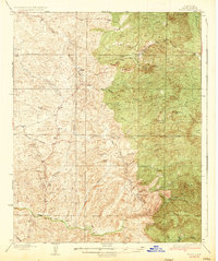
1935 Map of Woody
USGS Topo · Published 1935About this map
Mining and ranching activity define this portion of Kern County in the mid-1930s, where the foothills meet the Sequoia National Forest. The settlement at Woody serves as a local hub, supported by the Woody Sch and a segment of the State Highway. To the south, Granite Sta and Poso Flat anchor a landscape shaped by water and mineral extraction. Evidence of the region's industrial footprint is visible at the Long Tom Mine and Poso Mine, while the infrastructure of the Poso Irrigation District and a prominent Transmission Line underscore the area's development. The terrain is marked by distinctive landmarks such as Mon Bluff, Chalk Cliff, and the winding path of Poso Creek, illustrating the transition from the rugged highlands of Iron Mtn to the alluvial canyons of the Adobe Canyon and Granite Canyon.
Find a feature on this map
33 named features on this map. Tap any name to fly to it.
Don’t see what you’re looking for? This feature index may not catch every label — zoom into the map to look around manually.
Map Details
Editions of this 1935 Woody Map
2 editions found

Other maps of this area

1906 · Bakersfield
USGS Topo · 1:62,500

1910 · Buena Vista Lake
USGS Topo · 1:125,000

1912 · Buena Vista Lake
USGS Topo · 1:125,000

1914 · Caliente
USGS Topo · 1:125,000

1920 · Delonagha
USGS Topo · 1:62,500

1926 · Quincy School
USGS Topo · 1:31,680

1926 · Glennville
USGS Topo · 1:62,500

1929 · Richgrove
USGS Topo · 1:31,680

1929 · Quincy School
USGS Topo · 1:31,680

1930 · Oildale
USGS Topo · 1:31,680