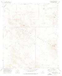
1973 Map of Woolsey Peak
USGS Topo · Published 1975About this map
The Gila Bend Mountains dominate this 1970s landscape, a terrain defined by arid summits and the critical infrastructure of the Southwest. Resource extraction is evident across the northern slopes, where historical operations such as the Idazona Mines and Morgan Mine are documented alongside several unnamed Prospect sites. Water, the most vital and scarce commodity in the Maricopa County desert, is managed through a network of isolated improvements including Jagow Tank, Webb Well, and several numbered wells like Gable Well No 1. The presence of the Southern Pacific Pipeline in the northwest corner highlights the area's role as a transit corridor for energy and utilities. High points like Woolsey Peak and Signal Mountain provide natural surveying landmarks, while Woolsey Wash serves as the primary drainage route through this remote desert environment.
Find a feature on this map
16 named features on this map. Tap any name to fly to it.
Don’t see what you’re looking for? This feature index may not catch every label — zoom into the map to look around manually.
Map Details
Editions of this 1973 Woolsey Peak Map
This is the sole edition of this map. No revisions or reprints were ever made.
Other maps of this area

1942 · Vicksburg
USGS Topo · 1:250,000

1951 · Dendora Valley
USGS Topo · 1:62,500

1951 · Woolsey Peak
USGS Topo · 1:62,500

1954 · Phoenix
USGS Topo · 1:250,000

1957 · Phoenix
USGS Topo · 1:250,000

1958 · Phoenix
USGS Topo · 1:250,000

1960 · Phoenix
USGS Topo · 1:250,000

1962 · Cortez Peak
USGS Topo · 1:62,500

1962 · Arlington
USGS Topo · 1:62,500

1969 · Phoenix
USGS Topo · 1:250,000