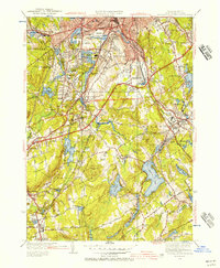
1948 Map of Worcester South
USGS Topo · Published 1956About this map
The Blackstone River and its numerous tributaries and reservoirs drive the character of the landscape south of Worcester just after World War II. The map reveals a region transitioning through industrial and infrastructure developments, most notably featuring the Massachusetts Turnpike under construction as it cuts across the center of the sheet. Urban expansion from Worcester is evident in the dense street grids of Quinsigamond and the sprawling facilities of the Worcester Sewage Disposal Plant.
Find a feature on this map
105 named features on this map. Tap any name to fly to it.
Don’t see what you’re looking for? This feature index may not catch every label — zoom into the map to look around manually.
Map Details
Editions of this 1948 Worcester South Map
2 editions found
Other maps of this area

1885 · Worcester
USGS Topo · 1:62,500

1886 · Worcester
USGS Topo · 1:62,500

1886 · Blackstone
USGS Topo · 1:62,500

1887 · Marlboro
USGS Topo · 1:62,500

1889 · Marlboro
USGS Topo · 1:62,500

1889 · Blackstone
USGS Topo · 1:62,500

1889 · Webster
USGS Topo · 1:62,500

1892 · Webster
USGS Topo · 1:62,500

1892 · Worcester
USGS Topo · 1:62,500

1893 · Blackstone
USGS Topo · 1:62,500