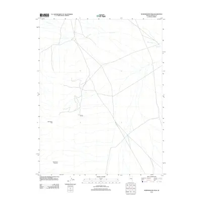
2012 Map of Worthington Peak
USGS Topo · Published 2012About this map
Worthington Peak dominates the high desert terrain of the Worthington Mountains in this remote section of Lincoln County. The landscape is defined by its isolation, where transportation is funneled through the arid basin via Mail Summit Rd. A notable point of human history is the Freiburg Post Office, which serves as a solitary landmark of civic infrastructure in an otherwise sparsely populated environment. Water resources are critical but scarce in this region, marked by the presence of Barton Creek and the Cottonwood Reservoir. These features suggest a history of localized water management necessary for survival and transit in the Nevada desert.
Find a feature on this map
6 named features on this map. Tap any name to fly to it.
Don’t see what you’re looking for? This feature index may not catch every label — zoom into the map to look around manually.
Map Details
Editions of this 2012 Worthington Peak Map
This is the sole edition of this map. No revisions or reprints were ever made.
Other maps of this area

1942 · Penoyer Valley
USGS Topo · 1:125,000

1954 · Caliente
USGS Topo · 1:250,000

1956 · Lund
USGS Topo · 1:250,000

1959 · Caliente
USGS Topo · 1:250,000

1960 · Lund
USGS Topo · 1:250,000

1985 · Worthington Peak
USGS Topo · 1:24,000

1985 · McCutchen Spring
USGS Topo · 1:24,000

1985 · Murphy Gap
USGS Topo · 1:24,000
1985 · Badger Gulch
USGS Topo · 1:24,000

1985 · Worthington Peak SW
USGS Topo · 1:24,000