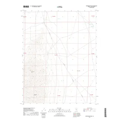
2018 Map of Worthington Peak
USGS Topo · Published 2018About this map
Worthington Peak dominates the western topography of this Lincoln County survey, forming the high point of the Worthington Mountains. To the east, the landscape transitions into the broad expanse of Garden Valley, where the drainage of Barton Cr flows toward Cottonwood Reservoir. The spatial organization of the area is defined by Mail Summit Rd, which traverses the valley floor and provides the primary corridor through this high-desert environment. This map captures the region's character as an intersection of prominent mountain terrain and open basin land, illustrating the relationship between the elevated peaks and the low-lying valley used for transit and water storage.
Find a feature on this map
14 named features on this map. Tap any name to fly to it.
Don’t see what you’re looking for? This feature index may not catch every label — zoom into the map to look around manually.
Map Details
Editions of this 2018 Worthington Peak Map
This is the sole edition of this map. No revisions or reprints were ever made.
Other maps of this area

1942 · Penoyer Valley
USGS Topo · 1:125,000

1954 · Caliente
USGS Topo · 1:250,000

1956 · Lund
USGS Topo · 1:250,000

1959 · Caliente
USGS Topo · 1:250,000

1960 · Lund
USGS Topo · 1:250,000

1985 · Worthington Peak
USGS Topo · 1:24,000

1985 · McCutchen Spring
USGS Topo · 1:24,000

1985 · Murphy Gap
USGS Topo · 1:24,000
1985 · Badger Gulch
USGS Topo · 1:24,000

1985 · Worthington Peak SW
USGS Topo · 1:24,000