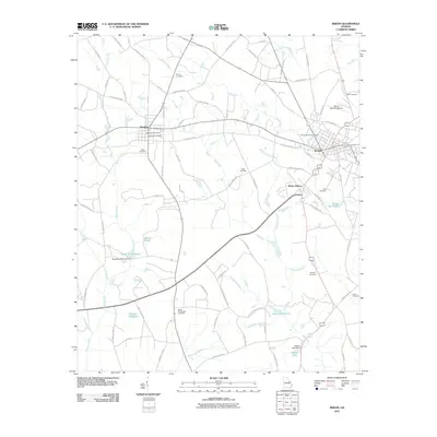
2011 Map of Wrens
USGS Topo · Published 2011About this map
Wrens and Stapleton anchor this Jefferson County landscape, where the agricultural traditions of eastern Georgia are marked by numerous family and community burial grounds. Several millponds, including Stapleton Millpond and Gamble Mill Pond, indicate a history of water-powered industry along the regional drainages of Big Creek and Duhart Creek. The map documents a transition from traditional rural routes like Stone Springfield Chur Rd and Old Stapleton Rd to modern infrastructure like the Wrens Memorial Airport. Local genealogy is well-represented through numerous dedicated plots such as Berryhill Cemetery, Vining Cemetery, and Stone Springfield Cemetery. South of the main settlements, the topography is defined by the convergence of several branches, including Fishpond Branch and Stephens Branch, which feed into larger local ponds and reservoirs like Adams Lake.
Find a feature on this map
84 named features on this map. Tap any name to fly to it.
Don’t see what you’re looking for? This feature index may not catch every label — zoom into the map to look around manually.
Map Details
Editions of this 2011 Wrens Map
This is the sole edition of this map. No revisions or reprints were ever made.
Other maps of this area

1920 · Stapleton
USGS Topo · 1:62,500

1922 · Harlem
USGS Topo · 1:62,500

1948 · Harlem
USGS Topo · 1:62,500

1948 · Stapleton
USGS Topo · 1:62,500

1948 · Louisville
USGS Topo · 1:24,000

1950 · Louisville
USGS Topo · 1:24,000

1950 · Wrens
USGS Topo · 1:24,000

1950 · Matthews
USGS Topo · 1:24,000
1950 · Bowdens Pond
USGS Topo · 1:24,000

1950 · Kellys Pond
USGS Topo · 1:24,000