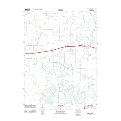
2012 Map of Wright City
USGS Topo · Published 2012About this map
Wright City sits as a central hub in this Missouri landscape, where the corridor of the Veterans Memorial Pkwy and Interstate 70 facilitates transit through Warren County. The northern section of the map is defined by agricultural lands and drainages like Indian Camp Creek and Hickory-Lick-Creek, while the south reveals a distinctive cluster of managed water bodies. This southern concentration, centered around Innsbrook, features a dense network of private lakes including Lake Lucern, End Brook Lake, and Leprechaun Lake, indicating a shift toward recreational and residential development away from the traditional farmstead patterns seen elsewhere. Smaller settlements such as Midway Vlg and local landmarks like Mount Airy Cemetery provide points of interest for genealogists. The presence of specialized sites like the Passionist Fathers Lake and Boone Trail Farm Lake highlights the varied land use across this transition between the prairie and the creek valleys of Peruque Creek and Charrette Creek.
Find a feature on this map
102 named features on this map. Tap any name to fly to it.
Don’t see what you’re looking for? This feature index may not catch every label — zoom into the map to look around manually.
Map Details
Editions of this 2012 Wright City Map
This is the sole edition of this map. No revisions or reprints were ever made.
Other maps of this area

1890 · Hermann
USGS Topo · 1:125,000

1903 · O'Fallon
USGS Topo · 1:125,000

1941 · Troy
USGS Topo · 1:62,500

1943 · Warrenton
USGS Topo · 1:62,500

1945 · Troy
USGS Topo · 1:62,500

1945 · Warrenton
USGS Topo · 1:62,500

1948 · Washington
USGS Topo · 1:62,500

1948 · Augusta
USGS Topo · 1:62,500

1949 · Saint Louis
USGS Topo · 1:250,000
1949 · Washington
USGS Topo · 1:62,500