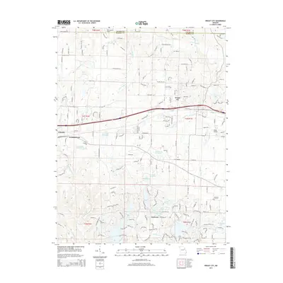
2015 Map of Wright City
USGS Topo · Published 2015About this map
Wright City serves as the central hub of this Missouri landscape, situated along the Norfolk Southern rail line and Interstate 70. This 2015 survey illustrates a mix of traditional agricultural land and modern residential developments, particularly in the southern portion near Innsbrook. The geography is defined by a series of small, private lakes and creek systems, including Peruque Cr and Charrette Cr. Notable religious and community sites such as Passionist Fathers Lake and the Mount Airy Cemetery offer specific points of interest for local historians and genealogists. The presence of specialized infrastructure like the C E E Airport and Fawn Lake Airport indicates the regional significance of small-scale aviation. The northern reaches show a transition into more forested terrain toward Skunk Hollow, while the western edge reaches the community of Truesdale.
Find a feature on this map
84 named features on this map. Tap any name to fly to it.
Don’t see what you’re looking for? This feature index may not catch every label — zoom into the map to look around manually.
Map Details
Editions of this 2015 Wright City Map
This is the sole edition of this map. No revisions or reprints were ever made.
Other maps of this area

1890 · Hermann
USGS Topo · 1:125,000

1903 · O'Fallon
USGS Topo · 1:125,000

1941 · Troy
USGS Topo · 1:62,500

1943 · Warrenton
USGS Topo · 1:62,500

1945 · Troy
USGS Topo · 1:62,500

1945 · Warrenton
USGS Topo · 1:62,500

1948 · Washington
USGS Topo · 1:62,500

1948 · Augusta
USGS Topo · 1:62,500

1949 · Saint Louis
USGS Topo · 1:250,000
1949 · Washington
USGS Topo · 1:62,500