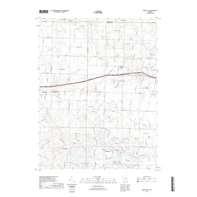
2017 Map of Wright City
USGS Topo · Published 2017About this map
Wright City and the neighboring seat of Warrenton anchor this 2017 survey of eastern Warren County, Missouri. The landscape is defined by the headwaters of several prominent drainage systems, including Hickory Lick Creek and Charrette Creek, which carve through the terrain south of Interstate 70. Significant institutional and community landmarks are scattered across the quadrangle, from the Boone Trail School to the Mount Airy Cemetery. The southern portion of the map highlights the development of Innsbrook, a resort community characterized by a high density of small water bodies like Lake Lucern and Leprechaun Lake. Farther north, agricultural and rural interests are evident in named properties such as Poor Boy Ranch and Cedar Knoll Farm Lake, while the western edge is buffered by the woodlands of the Reifsnider State Forest. Local aviation is represented by C E F Airport and Fawn Lake Airport.
Find a feature on this map
164 named features on this map. Tap any name to fly to it.
Don’t see what you’re looking for? This feature index may not catch every label — zoom into the map to look around manually.
Map Details
Editions of this 2017 Wright City Map
This is the sole edition of this map. No revisions or reprints were ever made.
Other maps of this area

1890 · Hermann
USGS Topo · 1:125,000

1903 · O'Fallon
USGS Topo · 1:125,000

1941 · Troy
USGS Topo · 1:62,500

1943 · Warrenton
USGS Topo · 1:62,500

1945 · Troy
USGS Topo · 1:62,500

1945 · Warrenton
USGS Topo · 1:62,500

1948 · Washington
USGS Topo · 1:62,500

1948 · Augusta
USGS Topo · 1:62,500

1949 · Saint Louis
USGS Topo · 1:250,000
1949 · Washington
USGS Topo · 1:62,500