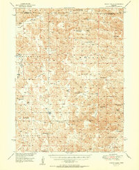
1951 Map of Wright Valley
USGS Topo · Published 1951About this map
Wright Valley and the surrounding Sandhills of McPherson County are defined by a network of family-run operations and isolated rural institutions during the mid-twentieth century. This survey, compiled from 1946 aerial photography, reveals a dispersed cattle-ranching economy where homesteads like Connell Ranch, Pinkerton Ranch, and Qualley Ranch serve as the primary landmarks across the rolling terrain. The map captures the social infrastructure of this sparsely populated landscape through its numbered educational centers, including School No 52 and School No 58, which were often the only community hubs for miles.
Find a feature on this map
38 named features on this map. Tap any name to fly to it.
Don’t see what you’re looking for? This feature index may not catch every label — zoom into the map to look around manually.
Map Details
Editions of this 1951 Wright Valley Map
2 editions found

Other maps of this area

1898 · Paxton
USGS Topo · 1:125,000

1899 · North Platte
USGS Topo · 1:125,000

1901 · Paxton
USGS Topo · 1:125,000

1902 · North Platte
USGS Topo · 1:125,000

1947 · Dismal River Ranch
USGS Topo · 1:62,500

1948 · Carr Lake
USGS Topo · 1:62,500

1949 · Dismal River Ranch
USGS Topo · 1:62,500

1949 · Flats
USGS Topo · 1:62,500

1949 · Wright Valley
USGS Topo · 1:62,500

1950 · Flats
USGS Topo · 1:62,500