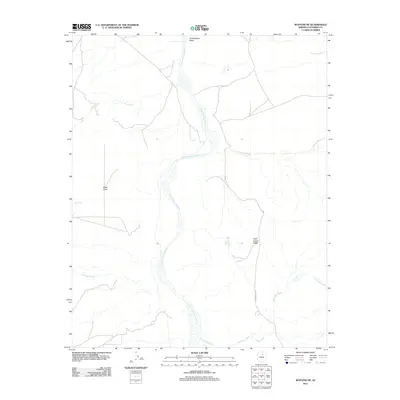
2011 Map of Wupatki NE
USGS Topo · Published 2011About this map
The Little Colorado River winds through this high desert terrain in Coconino County, carving a path through a landscape defined by seasonal washes and prominent ridges. This 2011 survey highlights the arid geography of the Colorado Plateau, where water sources like Yellow Spring and Ely Tank provide critical focal points in an otherwise dry expanse. The terrain is marked by significant natural landmarks, including the dark basalt of Black Point and the elevated stretch of Baah Lokaa Ridge. Human infrastructure is sparse, primarily represented by Indian Rte 6730, which traverses the eastern portion of the map. The drainage patterns are clearly visible through the numerous tributary washes such as Kish Zhini Wash, Mays Wash, and Jackrabbit Wash, reflecting the complex erosion of this northeastern Arizona region.
Find a feature on this map
12 named features on this map. Tap any name to fly to it.
Don’t see what you’re looking for? This feature index may not catch every label — zoom into the map to look around manually.
Map Details
Editions of this 2011 Wupatki NE Map
This is the sole edition of this map. No revisions or reprints were ever made.
Other maps of this area

1886 · San Francisco Mtns
USGS Topo · 1:250,000

1891 · San Francisco Mtns
USGS Topo · 1:250,000

1894 · San Francisco Mtns
USGS Topo · 1:250,000

1899 · San Francisco Mtns
USGS Topo · 1:250,000

1947 · Flagstaff
USGS Topo · 1:250,000

1954 · Flagstaff
USGS Topo · 1:250,000

1955 · Black Falls 4 SW
USGS Topo · 1:24,000

1955 · Black Falls NE
USGS Topo · 1:24,000

1955 · Cameron SW
USGS Topo · 1:24,000
1955 · Cameron SE
USGS Topo · 1:24,000