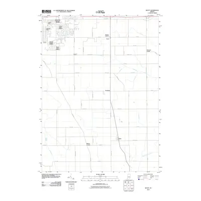
2010 Map of Wyatt
USGS Topo · Published 2010About this map
South Bend transitions into a structured landscape of agricultural tracts and residential subdivisions in this survey of Saint Joseph County. The northern portion of the map illustrates the southward expansion of the city through neighborhoods like Gilmer Park, Crest Manor Addition, and Miami Trails Addition. These modern developments are anchored by older landmarks such as Southlawn Cemetery, reflecting the long-term growth patterns of the region.
Find a feature on this map
37 named features on this map. Tap any name to fly to it.
Don’t see what you’re looking for? This feature index may not catch every label — zoom into the map to look around manually.
Map Details
Editions of this 2010 Wyatt Map
This is the sole edition of this map. No revisions or reprints were ever made.
Other maps of this area

1953 · Chicago
USGS Topo · 1:250,000

1957 · Chicago
USGS Topo · 1:250,000

1958 · South Bend East
USGS Topo · 1:24,000

1958 · South Bend West
USGS Topo · 1:24,000

1958 · Bremen
USGS Topo · 1:24,000

1958 · La Paz
USGS Topo · 1:24,000

1958 · Nappanee West
USGS Topo · 1:24,000

1958 · Osceola
USGS Topo · 1:24,000

1958 · Lakeville
USGS Topo · 1:24,000
1961 · Wakarusa
USGS Topo · 1:24,000
Featured Places
- South Bend, IN
- Mishawaka, IN
- Midway Corners, IN
- Crest Manor Addition, South Bend
- Orchard Heights Addition, IN