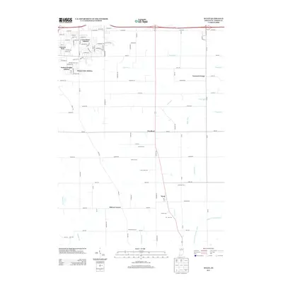
2013 Map of Wyatt
USGS Topo · Published 2013About this map
Wyatt and the agricultural lands south of South Bend are documented in this 2013 survey, showing a landscape defined by organized drainage and family-owned farmsteads. The settlement of Woodland sits at a central crossroads, while residential expansion is visible to the northwest in neighborhoods like Crest Manor Addition and Orchard Heights Addition. This map is particularly notable for its specific labeling of established agricultural operations, including Schmidt Farms, Freehauf Farm, and Good Brothers Farm, providing a rare level of detail for local genealogy and land-use studies.
Find a feature on this map
72 named features on this map. Tap any name to fly to it.
Don’t see what you’re looking for? This feature index may not catch every label — zoom into the map to look around manually.
Map Details
Editions of this 2013 Wyatt Map
This is the sole edition of this map. No revisions or reprints were ever made.
Other maps of this area

1953 · Chicago
USGS Topo · 1:250,000

1957 · Chicago
USGS Topo · 1:250,000

1958 · South Bend East
USGS Topo · 1:24,000

1958 · South Bend West
USGS Topo · 1:24,000

1958 · Bremen
USGS Topo · 1:24,000

1958 · La Paz
USGS Topo · 1:24,000

1958 · Nappanee West
USGS Topo · 1:24,000

1958 · Osceola
USGS Topo · 1:24,000

1958 · Lakeville
USGS Topo · 1:24,000
1961 · Wakarusa
USGS Topo · 1:24,000
Featured Places
- South Bend, IN
- Mishawaka, IN
- Midway Corners, IN
- Crest Manor Addition, South Bend
- Orchard Heights Addition, IN