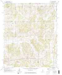
1971 Map of Wyatte
USGS Topo · Published 1973About this map
Wyatte sits at the intersection of rural roads in the southern half of this 1970s landscape, serving as a central point for the surrounding farming communities. The area is defined by its numerous small congregational centers and family burial grounds, reflecting a deeply rooted social structure across the Tate and Marshall county line. Large drainage systems like Hickahala Creek and Cuffawa Creek cross the terrain, their bottomlands providing a contrast to the upland settlements of Wallhill and Wakefield. Genealogy researchers will find significant value in the distribution of historic sites, from the St Josephs Ch in the north to Roberts Chapel and the Shady Grove Ch Cem. The presence of a Gaging Station on Cuffawa Creek and a Radio Tower near Orion indicates the subtle infrastructure supporting this agricultural region during the early 1970s.
Find a feature on this map
31 named features on this map. Tap any name to fly to it.
Don’t see what you’re looking for? This feature index may not catch every label — zoom into the map to look around manually.
Map Details
Editions of this 1971 Wyatte Map
2 editions found
Other maps of this area

1944 · Senatobia
USGS Topo · 1:62,500

1944 · Hernando
USGS Topo · 1:62,500

1944 · Tyro
USGS Topo · 1:62,500

1948 · Byhalia
USGS Topo · 1:62,500

1956 · Tupelo
USGS Topo · 1:250,000

1958 · Tupelo
USGS Topo · 1:250,000
1971 · Byhalia
USGS Topo · 1:24,000
1971 · Marianna
USGS Topo · 1:24,000

1971 · Wyatte
USGS Topo · 1:24,000

1971 · Laws Hill
USGS Topo · 1:24,000