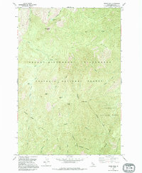
1991 Map of Wylies Peak
USGS Topo · Published 1995About this map
Wylies Peak, topped with a high-elevation Lookout, commands the northern reaches of this landscape within the Selway - Bitterroot Wilderness. This high-country terrain is defined by a series of prominent divides, including Wylies Ridge and Saddle Blanket Ridge, which separate deep drainages such as Elk Creek and Goat Creek. The map documents a strictly non-motorized landscape where travel is restricted to a historic Pack Trail system, reflecting the preservation of the Nez Perce National Forest and neighboring Bitterroot National Forest.
Find a feature on this map
29 named features on this map. Tap any name to fly to it.
Don’t see what you’re looking for? This feature index may not catch every label — zoom into the map to look around manually.
Map Details
Editions of this 1991 Wylies Peak Map
This is the sole edition of this map. No revisions or reprints were ever made.
Other maps of this area

1911 · Lolo
USGS Topo · 1:250,000

1913 · Lolo
USGS Topo · 1:250,000

1956 · Elk City
USGS Topo · 1:250,000

1956 · Hamilton
USGS Topo · 1:250,000

1959 · Hamilton
USGS Topo · 1:250,000

1960 · Elk City
USGS Topo · 1:250,000

1960 · Hamilton
USGS Topo · 1:250,000

1964 · Hamilton
USGS Topo · 1:250,000

1966 · Spot Mountain
USGS Topo · 1:24,000

1966 · Moose Ridge
USGS Topo · 1:24,000