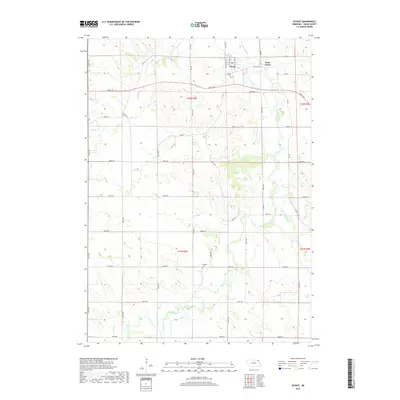
2017 Map of Wynot
USGS Topo · Published 2017About this map
Wynot sits in the northern reaches of Cedar County, serving as a primary point of settlement within a landscape defined by the branching waters of the Bow Creek system. This 2017 survey illustrates the rural character of the region, where agricultural sections are neatly divided by a grid of numbered roads like 890th Rd and 567th Ave. The map preserves the locations of local landmarks such as Wynot Cem and the more isolated Paragon Cem to the south, which offer valuable data points for those researching family history in this part of Nebraska. The terrain is deeply carved by the flow of W Bow Cr, East Bow Creek, and Dead Cr, showing the natural drainage patterns that have influenced land use and road placement since the area was first settled. To the northeast, the smaller community of Saint James remains a notable geographic feature near the boundary of T32N R3E.
Find a feature on this map
37 named features on this map. Tap any name to fly to it.
Don’t see what you’re looking for? This feature index may not catch every label — zoom into the map to look around manually.
Map Details
Editions of this 2017 Wynot Map
This is the sole edition of this map. No revisions or reprints were ever made.
Other maps of this area

1955 · Sioux City
USGS Topo · 1:250,000

1958 · Sioux City
USGS Topo · 1:250,000

1959 · Sioux City
USGS Topo · 1:250,000

1968 · Obert
USGS Topo · 1:24,000

1968 · St. Helena
USGS Topo · 1:24,000

1968 · Coleridge
USGS Topo · 1:24,000

1968 · Hartington
USGS Topo · 1:24,000

1968 · Wynot
USGS Topo · 1:24,000
1968 · Meckling
USGS Topo · 1:24,000
1968 · Coleridge SE
USGS Topo · 1:24,000