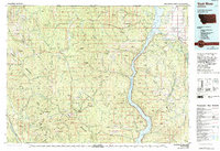
1979 Map of Yaak River
USGS Topo · Published 1993About this map
Lake Koocanusa dominates the eastern drainage of this 1970s landscape, a massive reservoir created by the damming of the Kootenai River. The map shows a region of intensive topographic observation, evidenced by an extensive network of fire lookouts including Lookout Tower Northwest Peak and Lookout Tower Garver Mountain perched atop the Purcell Mountains. These towers were critical for protecting the timber resources of the Kootenai National Forest.
Find a feature on this map
64 named features on this map. Tap any name to fly to it.
Don’t see what you’re looking for? This feature index may not catch every label — zoom into the map to look around manually.
Map Details
Editions of this 1979 Yaak River Map
This is the sole edition of this map. No revisions or reprints were ever made.
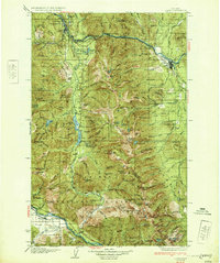
Other maps of this area

1911 · Priest Lake
USGS Topo · 1:250,000

1913 · Priest Lake
USGS Topo · 1:250,000

1913 · Stryker
USGS Topo · 1:125,000

1916 · Stryker
USGS Topo · 1:125,000

1920 · Libby
USGS Topo · 1:125,000

1920 · Jennings
USGS Topo · 1:125,000

1930 · Libby
USGS Topo · 1:125,000
1932 · Libby
USGS Topo · 1:125,000

1935 · Thompson Lakes
USGS Topo · 1:96,000

1942 · Thompson Lakes
USGS Topo · 1:125,000