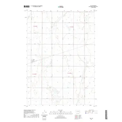
2017 Map of Yale
USGS Topo · Published 2017About this map
Yale anchors this agricultural landscape in Beadle County, where the street grid of the town site—including Main St, 2nd St, and 3rd St—stands in contrast to the surrounding section lines. The rural character of the area is defined by its watercourses and small community landmarks, most notably the Pearl Cr and its tributary Middle Pearl Cr, which wind through the township. For those researching family history in this part of South Dakota, the map identifies two distinct burial grounds: Trinity Cem located north of town near 413th Ave and Dixon Cem to the southeast. The rigid survey grid is maintained by a network of local roads such as Co Rd 31 and numerous numbered avenues, which provide access to the dispersed farmsteads characteristic of the Great Plains.
Find a feature on this map
27 named features on this map. Tap any name to fly to it.
Don’t see what you’re looking for? This feature index may not catch every label — zoom into the map to look around manually.
Map Details
Editions of this 2017 Yale Map
This is the sole edition of this map. No revisions or reprints were ever made.
Other maps of this area

1895 · Byron
USGS Topo · 1:125,000

1898 · Huron
USGS Topo · 1:125,000

1899 · De Smet
USGS Topo · 1:125,000

1953 · Huron
USGS Topo · 1:250,000

1953 · Watertown
USGS Topo · 1:250,000

1954 · Huron
USGS Topo · 1:250,000

1956 · Lake Byron SE
USGS Topo · 1:24,000

1957 · Cavour
USGS Topo · 1:24,000

1958 · Watertown
USGS Topo · 1:250,000
1958 · Huron NE
USGS Topo · 1:24,000