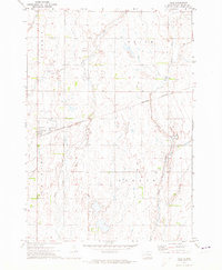
1971 Map of Yale
USGS Topo · Published 1973About this map
Yale anchors this Beadle County landscape as it appeared in the early 1970s, positioned along the Burlington Northern railroad line. The settlement pattern is defined by the intersections of several townships, including Liberty, Foster, and Banner. The terrain is characterized by a high density of small depressional wetlands and intermittent watercourses, most notably Pearl Creek and its tributary, Middle Pearl Creek, which meander through the prairie landscape.
Find a feature on this map
11 named features on this map. Tap any name to fly to it.
Don’t see what you’re looking for? This feature index may not catch every label — zoom into the map to look around manually.
Map Details
Editions of this 1971 Yale Map
This is the sole edition of this map. No revisions or reprints were ever made.
Other maps of this area

1895 · Byron
USGS Topo · 1:125,000

1898 · Huron
USGS Topo · 1:125,000

1899 · De Smet
USGS Topo · 1:125,000

1953 · Huron
USGS Topo · 1:250,000

1953 · Watertown
USGS Topo · 1:250,000

1954 · Huron
USGS Topo · 1:250,000

1956 · Lake Byron SE
USGS Topo · 1:24,000

1957 · Cavour
USGS Topo · 1:24,000

1958 · Watertown
USGS Topo · 1:250,000
1958 · Huron NE
USGS Topo · 1:24,000