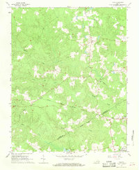
1966 Map of Yale
USGS Topo · Published 1968About this map
The borderlands of Sussex and Southampton counties in the mid-1960s are defined by a network of rural hamlets and timber-rich bottomlands. Small settlements such as Yale, Hilda, and Gray anchor the landscape, which is bisected by the Norfolk and Western railway. The influence of early 20th-century industry is evident in the presence of an Old Railroad Grade and the Rivers Mill site located near Rivers Pond at the southern edge of the survey. The community's social fabric is visible through scattered congregations like Russian Ch, Calvary Ch, and Center Star Ch. To the southeast, the expansive Southampton Correctional Farm occupies a significant portion of the terrain above Hornet Swamp and Poplar Swamp, illustrating the large-scale institutional land use common in this part of Virginia.
Find a feature on this map
20 named features on this map. Tap any name to fly to it.
Don’t see what you’re looking for? This feature index may not catch every label — zoom into the map to look around manually.
Map Details
Editions of this 1966 Yale Map
3 editions found
Other maps of this area

1919 · Jarratt
USGS Topo · 1:62,500

1919 · Homeville
USGS Topo · 1:48,000

1919 · Boykins
USGS Topo · 1:48,000

1919 · Arringdale
USGS Topo · 1:48,000

1920 · Homeville
USGS Topo · 1:62,500

1920 · Boykins
USGS Topo · 1:62,500

1920 · Arringdale
USGS Topo · 1:62,500

1942 · Arringdale
USGS Topo · 1:62,500

1943 · Sebrell
USGS Topo · 1:31,680

1943 · Littleton
USGS Topo · 1:31,680