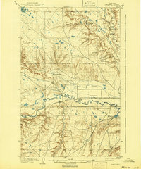
1904 Map of Yantic
USGS Topo · Published 1941About this map
Isolated homesteads and extensive ranching operations define this northern Montana landscape, surveyed at the start of the 20th century. The Great Northern R. R. follows the meandering course of the Milk River, providing a vital transportation artery for the region's livestock economy. Family-named outposts such as Empire Ranch, Thibedeau's Ranch, and Reser's Ranch are scattered across a terrain carved by numerous coulees, including Wallace Coulee and Riddle Coulee.
Find a feature on this map
26 named features on this map. Tap any name to fly to it.
Don’t see what you’re looking for? This feature index may not catch every label — zoom into the map to look around manually.
Map Details
Editions of this 1904 Yantic Map
2 editions found
Other maps of this area

1904 · Yantic
USGS Topo · 1:62,500

1904 · Chinook
USGS Topo · 1:62,500

1904 · Havre
USGS Topo · 1:62,500

1912 · Zurich
USGS Topo · 1:125,000

1912 · Thibedeau Lake
USGS Topo · 1:125,000

1953 · Havre
USGS Topo · 1:250,000

1956 · Lloyd
USGS Topo · 1:62,500

1956 · Cleveland
USGS Topo · 1:62,500

1957 · Havre
USGS Topo · 1:250,000

1958 · Havre
USGS Topo · 1:250,000