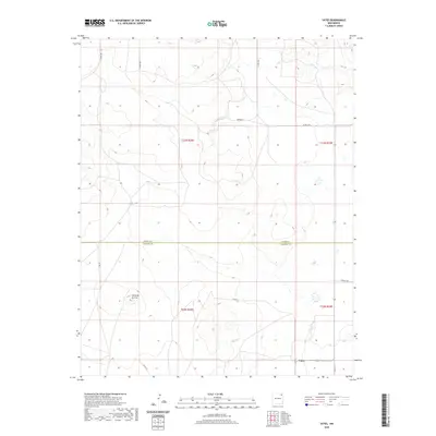
2020 Map of Yates
USGS Topo · Published 2020About this map
Yates sits at the junction of High Plains roads in the northeast corner of New Mexico, a region defined by wide-open grazing land and occasional volcanic landmarks. The landscape is punctuated by Cerro de la Cruz, a prominent rise that serves as a topographical anchor in an area otherwise marked by subtle drainage patterns and occasional wetlands. This 2020 edition provides a clear picture of modern land divisions, showing the precise boundary between Union Co and Harding Co. Local infrastructure is mapped through a grid of rural routes including Charles Rd, Merger Ln, and several county roads such as Co RD Z-1. The map illustrates how township and range lines, like t23n r28e, continue to organize the agricultural and ranching economy of this sparsely populated high desert territory.
Find a feature on this map
16 named features on this map. Tap any name to fly to it.
Don’t see what you’re looking for? This feature index may not catch every label — zoom into the map to look around manually.
Map Details
Editions of this 2020 Yates Map
This is the sole edition of this map. No revisions or reprints were ever made.
Other maps of this area

1954 · Raton
USGS Topo · 1:250,000

1954 · Dalhart
USGS Topo · 1:250,000

1958 · Raton
USGS Topo · 1:250,000

1958 · Dalhart
USGS Topo · 1:250,000

1962 · Dalhart
USGS Topo · 1:250,000

1973 · Yates SE
USGS Topo · 1:24,000

1973 · Romero Spring
USGS Topo · 1:24,000
1973 · Valencia Spring
USGS Topo · 1:24,000
1974 · Kansas Valley
USGS Topo · 1:24,000

1974 · Farley
USGS Topo · 1:24,000