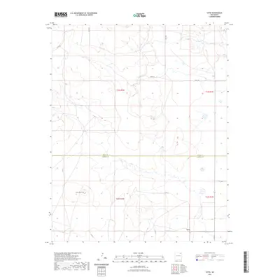
2023 Map of Yates
USGS Topo · Published 2023About this map
Yates stands as the central point of reference in this high-plains landscape where the northeastern corner of New Mexico meets the southern boundary of Union County. The topography is defined by the prominent Cerro de la Cruz, a landmark elevation that overlooks a network of rural routes including Co Rd C001 and Co Rd C006. This survey reveals the precise intersection of administrative lines at the Union Co Harding Co border, illustrating how political boundaries were laid across the open range. The sparse distribution of named roads like Merger Ln and Charles Rd reflects the enduring agricultural and ranching character of the region, where large parcels of land are divided by section lines and connected by a few critical transportation corridors.
Find a feature on this map
16 named features on this map. Tap any name to fly to it.
Don’t see what you’re looking for? This feature index may not catch every label — zoom into the map to look around manually.
Map Details
Editions of this 2023 Yates Map
This is the sole edition of this map. No revisions or reprints were ever made.
Other maps of this area

1954 · Raton
USGS Topo · 1:250,000

1954 · Dalhart
USGS Topo · 1:250,000

1958 · Raton
USGS Topo · 1:250,000

1958 · Dalhart
USGS Topo · 1:250,000

1962 · Dalhart
USGS Topo · 1:250,000

1973 · Yates SE
USGS Topo · 1:24,000

1973 · Romero Spring
USGS Topo · 1:24,000
1973 · Valencia Spring
USGS Topo · 1:24,000
1974 · Kansas Valley
USGS Topo · 1:24,000

1974 · Farley
USGS Topo · 1:24,000