1947 Map of Yauco SO
USGS Topo · Published 1947About this map
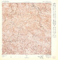
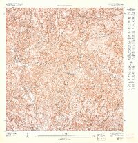
The town of Yauco serves as the central hub of this 1940s topography, situated at the base of the island's southern highlands. The map illustrates a dense urban grid bordered by the Río Yauco and the Quebrada Berrenchín, showcasing a landscape where mountainous terrain meets agricultural coastal plains. A critical piece of infrastructure, the Linea De American Porto Rico Railroad, cuts across the valley, signaling the importance of sugar transportation and regional connectivity during this era.
Find a feature on this map
12 named features on this map. Tap any name to fly to it.
Don’t see what you’re looking for? This feature index may not catch every label — zoom into the map to look around manually.
Map Details
Editions of this 1947 Yauco SO Map
This is the sole edition of this map. No revisions or reprints were ever made.
Historical Maps of Indios Through Time
4 maps found