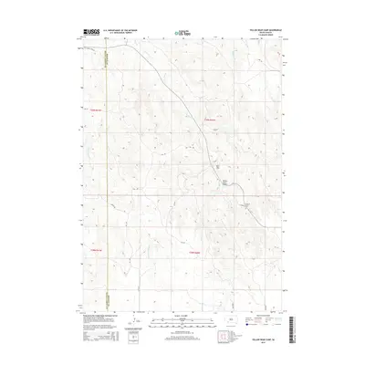
2015 Map of Yellow Bear Camp
USGS Topo · Published 2015About this map
Yellow Bear Camp and its surrounding prairie landscapes define this 2015 survey of the Oglala Lakota and Bennett County border. The geography is shaped by the winding course of No Flesh Cr as it carves through the terrain, flanked by significant features like Yellow Bear Canyon. The drainage patterns of Medicine Root Cr and Redwater Cr illustrate the natural irrigation of the Pine Ridge region, while a network of rural roads—named for local flora such as Ash Rd, Elm Rd, and Poplar Rd—connects the dispersed settlements and seasonal camps. A key cultural landmark, the Body of Christ Cem, sits in the southeast, serving as a primary point for genealogical research and community history in this part of South Dakota.
Find a feature on this map
22 named features on this map. Tap any name to fly to it.
Don’t see what you’re looking for? This feature index may not catch every label — zoom into the map to look around manually.
Map Details
Editions of this 2015 Yellow Bear Camp Map
This is the sole edition of this map. No revisions or reprints were ever made.
Other maps of this area

1955 · Hot Springs
USGS Topo · 1:250,000

1955 · Martin
USGS Topo · 1:250,000

1958 · Martin
USGS Topo · 1:250,000

1981 · Yellow Bear Camp
USGS Topo · 1:25,000

1981 · Allen
USGS Topo · 1:25,000

1981 · Kyle
USGS Topo · 1:25,000
1981 · Batesland
USGS Topo · 1:25,000

1981 · Hisle
USGS Topo · 1:25,000

1981 · Swett
USGS Topo · 1:25,000

1983 · Martin
USGS Topo · 1:100,000