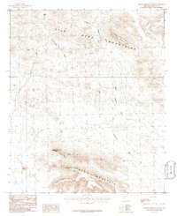
1986 Map of Yellow Medicine Butte
USGS Topo · Published 1986About this map
Gila Bend Mountains dominate this arid landscape, rising sharply above the desert floor in western Maricopa County. This mid-1980s topographical study reveals a terrain shaped by seasonal watercourses like Yellow Medicine Wash and Loudermilk Wash, which drain the high ridges toward the broad Hyder Valley below. Evidence of prospecting is scattered across the slopes, with several Mine Shafts and a Prospect located near the northern ridges, indicating the era's ongoing mineral exploration. Distinctive geological formations serve as primary navigational landmarks, most notably the prominent Yellow Medicine Butte and the tiered profile of Face Mountain to the south. The presence of Seep Tank in the northwest corner highlights the critical and rare water sources necessary for desert transit. Near the southern edge of the mountains, Montezuma Head stands as a significant vertical feature overlooking the alluvial plains.
Find a feature on this map
11 named features on this map. Tap any name to fly to it.
Don’t see what you’re looking for? This feature index may not catch every label — zoom into the map to look around manually.
Map Details
Editions of this 1986 Yellow Medicine Butte Map
This is the sole edition of this map. No revisions or reprints were ever made.
Other maps of this area

1927 · Hyder
USGS Topo · 1:62,500

1930 · Hyder
USGS Topo · 1:62,500

1942 · Vicksburg
USGS Topo · 1:250,000

1951 · Dendora Valley
USGS Topo · 1:62,500

1954 · Phoenix
USGS Topo · 1:250,000

1957 · Phoenix
USGS Topo · 1:250,000

1958 · Phoenix
USGS Topo · 1:250,000

1960 · Phoenix
USGS Topo · 1:250,000

1962 · Cortez Peak
USGS Topo · 1:62,500

1962 · Eagletail Mts
USGS Topo · 1:62,500