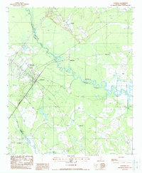
1988 Map of Yemassee
USGS Topo · Published 1988About this map
The Yemassee rail junction serves as a central hub in this Lowcountry landscape, where the Seaboard System railroad tracks intersect near the winding Combahee River. This 1980s-era survey reveals a transition between rural crossroads and established riverfront settlements across four county lines: Colleton, Hampton, Beaufort, and Jasper. Small community centers such as Blountville and Salkehatchie anchor the northern reaches, while the southern area is defined by the Pocotaligo River and the settlement of Pocotaligo. The topography is marked by significant marshlands and floodplains, particularly around the serpentine bends of the river, which have historically dictated the placement of landings and transport sidings like Blake Siding. Family-named sites and estates including Rose Hill, Brewton, and Tomotley suggest a lineage of land use tied to the coastal South Carolina river system.
Find a feature on this map
21 named features on this map. Tap any name to fly to it.
Don’t see what you’re looking for? This feature index may not catch every label — zoom into the map to look around manually.
Map Details
Editions of this 1988 Yemassee Map
This is the sole edition of this map. No revisions or reprints were ever made.
Other maps of this area

1918 · Walterboro
USGS Topo · 1:62,500

1918 · Green Pond
USGS Topo · 1:62,500

1918 · Yemassee
USGS Topo · 1:62,500

1919 · Cummings
USGS Topo · 1:62,500

1943 · Yemassee
USGS Topo · 1:62,500

1943 · Green Pond
USGS Topo · 1:62,500

1943 · Cummings
USGS Topo · 1:62,500

1943 · Walterboro
USGS Topo · 1:62,500

1947 · Savannah
USGS Topo · 1:250,000

1948 · Savannah
USGS Topo · 1:250,000