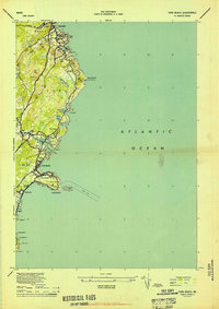
1944 Map of York Beach
USGS Topo · Published 1944About this map
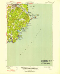
Ogunquit and the southern Maine coastline appear here during the mid-1940s, a landscape defined by rocky points and seasonal settlements. The map highlights the transition from a maritime economy to a coastal retreat, with the Ogunquit Country Club and various beachside communities like York Beach and York Cliffs punctuating the shore. Inland, the presence of the Old RR Grade running through the York Swamp points to former transportation corridors that once linked these seaside towns. Distinctive topographical features such as Bald Head Cliff and Cape Neddick Nubble anchor the shoreline, while the Cape Neddick LH serves as a vital navigational landmark near the entrance to the Cape Neddick River. Family names and local landmarks like Perkins Cove, Israels Head, and Simpsons Hill provide significant detail for those tracing the development of York and Wells at the height of the Second World War era.
Find a feature on this map
48 named features on this map. Tap any name to fly to it.
Don’t see what you’re looking for? This feature index may not catch every label — zoom into the map to look around manually.
Map Details
Editions of this 1944 York Beach Map
2 editions found

Other maps of this area

1891 · Biddeford
USGS Topo · 1:62,500

1891 · Kennebunk
USGS Topo · 1:62,500

1893 · Kennebunk
USGS Topo · 1:62,500

1893 · York
USGS Topo · 1:62,500

1893 · Biddeford
USGS Topo · 1:62,500

1898 · Kennebunk
USGS Topo · 1:62,500

1920 · York
USGS Topo · 1:62,500
1941 · Biddeford
USGS Topo · 1:62,500

1941 · Kennebunk
USGS Topo · 1:62,500

1944 · Wells
USGS Topo · 1:24,000