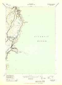
1944 Map of York Beach
USGS Topo · Published 1944About this map
The rocky Maine coastline between Wells and York is meticulously detailed in this mid-1940s wartime survey. Centered on the resort communities of York Beach and Ogunquit, the topography highlights the era's infrastructure, including the Old Rr Grade running parallel to the coast and the Cape Neddick LH on its iconic nubble. The map captures a high degree of coastal development in areas like Concordville, Oceanside, and York Cliffs, while preserving the natural character of landmarks such as Bald Head Cliff and Israels Head.
Find a feature on this map
54 named features on this map. Tap any name to fly to it.
Don’t see what you’re looking for? This feature index may not catch every label — zoom into the map to look around manually.
Map Details
Editions of this 1944 York Beach Map
2 editions found
Other maps of this area

1891 · Biddeford
USGS Topo · 1:62,500

1891 · Kennebunk
USGS Topo · 1:62,500

1893 · Kennebunk
USGS Topo · 1:62,500

1893 · York
USGS Topo · 1:62,500

1893 · Biddeford
USGS Topo · 1:62,500

1898 · Kennebunk
USGS Topo · 1:62,500

1920 · York
USGS Topo · 1:62,500

1941 · Biddeford
USGS Topo · 1:62,500

1941 · Kennebunk
USGS Topo · 1:62,500

1944 · Wells
USGS Topo · 1:24,000