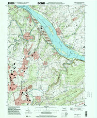
1999 Map of York Haven
USGS Topo · Published 2001About this map
Codorus Furnace stands near the confluence of Codorus Creek and the Susquehanna River, anchoring a landscape defined by industrial history and river navigation. The river itself is dominated by large landforms like Haldeman Island and the turbulent Conewago Falls to the north. Settlement is concentrated in the boroughs of Mount Wolf, Manchester, and York Haven, which are linked by historic transit corridors and educational centers like Northeastern High Sch.
Find a feature on this map
70 named features on this map. Tap any name to fly to it.
Don’t see what you’re looking for? This feature index may not catch every label — zoom into the map to look around manually.
Map Details
Editions of this 1999 York Haven Map
This is the sole edition of this map. No revisions or reprints were ever made.
Other maps of this area

1906 · New Cumberland
USGS Topo · 1:62,500

1908 · Middletown
USGS Topo · 1:62,500

1908 · York
USGS Topo · 1:62,500

1910 · York
USGS Topo · 1:62,500

1920 · Hanover
USGS Topo · 1:62,500

1922 · Hanover
USGS Topo · 1:62,500

1943 · New Cumberland
USGS Topo · 1:62,500

1943 · Middletown
USGS Topo · 1:62,500

1948 · Baltimore
USGS Topo · 1:250,000

1950 · Harrisburg
USGS Topo · 1:250,000