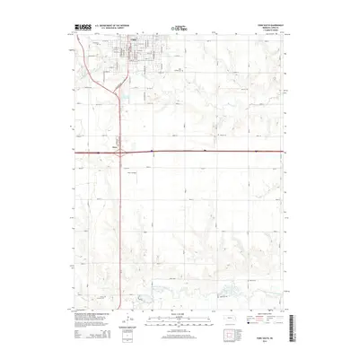
2014 Map of York South
USGS Topo · Published 2014About this map
The city of York dominates the northern edge of this Nebraska landscape, where the residential grid of streets like N Platte Ave and E 14th ST meets the grounds of York Coll. This 2014 survey captures the intersection of urban growth and rural agricultural land, extending south along Us-81 through the small settlement at Knox. The terrain is defined by the winding course of Beaver Creek and the West Fork Big Blue River, which carve through the plains near Sacks Lake and Wochner Reservoir. Genealogists will find several burial grounds across the quadrangle, ranging from the well-established Greenwood Cem and Saint Josephs Cem near the city to the more isolated Vernon Cem and Holoch Cem in the southern farmland.
Find a feature on this map
79 named features on this map. Tap any name to fly to it.
Don’t see what you’re looking for? This feature index may not catch every label — zoom into the map to look around manually.
Map Details
Editions of this 2014 York South Map
This is the sole edition of this map. No revisions or reprints were ever made.
Other maps of this area

1898 · York
USGS Topo · 1:125,000

1899 · York
USGS Topo · 1:125,000

1934 · Utica
USGS Topo · 1:62,500

1937 · Utica
USGS Topo · 1:62,500

1955 · Lincoln
USGS Topo · 1:250,000

1957 · Lincoln
USGS Topo · 1:250,000

1958 · Lincoln
USGS Topo · 1:250,000
1969 · York North
USGS Topo · 1:24,000
1969 · Utica SW
USGS Topo · 1:24,000

1969 · Fairmont
USGS Topo · 1:24,000