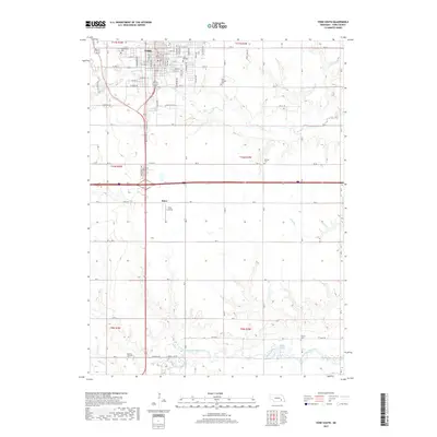
2017 Map of York South
USGS Topo · Published 2017About this map
York serves as the focal point of this agricultural and educational landscape, situated north of the West Fork Big Blue River. The town is the site of York College and is surrounded by a network of rural cemeteries including Greenwood Cem and Saint Josephs Cem, providing a detailed record for genealogical research. The topography is defined by the drainage patterns of Beaver Creek and Galaway Cr, which flow through a grid of section-line roads and homesteads. Further south, the community of Knox and the Knox Landing area appear along the principal north-south transit corridor. Water management and natural basins are evident through features like the Wochner Reservoir and Sucks Lake, which break the geometric regularity of the Nebraska prairie.
Find a feature on this map
58 named features on this map. Tap any name to fly to it.
Don’t see what you’re looking for? This feature index may not catch every label — zoom into the map to look around manually.
Map Details
Editions of this 2017 York South Map
This is the sole edition of this map. No revisions or reprints were ever made.
Other maps of this area

1898 · York
USGS Topo · 1:125,000

1899 · York
USGS Topo · 1:125,000

1934 · Utica
USGS Topo · 1:62,500

1937 · Utica
USGS Topo · 1:62,500

1955 · Lincoln
USGS Topo · 1:250,000

1957 · Lincoln
USGS Topo · 1:250,000

1958 · Lincoln
USGS Topo · 1:250,000
1969 · York North
USGS Topo · 1:24,000
1969 · Utica SW
USGS Topo · 1:24,000

1969 · Fairmont
USGS Topo · 1:24,000