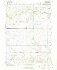
1969 Map of York SW
USGS Topo · Published 1971About this map
Beaver Creek and its tributaries carve a winding path across this agricultural landscape in York County, where the 1969 topography reveals a section of the Great Plains defined by orderly townships and growing modern infrastructure. The map documents a significant era of institutional and educational history, featuring the State Reformatory for Women in the northeast and Centennial Sch in the southeast. This period also captures the footprint of Interstate 80 bisecting the terrain, complete with a designated Rest Area. Rural life is anchored by local landmarks like Council Ch and Butler Cem, while the land itself is partitioned into sections under Bradshaw, Lockridge, Brown, Baker, Henderson, and Hays townships. Numerous wells dot the landscape, indicating the intensive water management required for the region's farming economy.
Find a feature on this map
19 named features on this map. Tap any name to fly to it.
Don’t see what you’re looking for? This feature index may not catch every label — zoom into the map to look around manually.
Map Details
Editions of this 1969 York SW Map
This is the sole edition of this map. No revisions or reprints were ever made.
Other maps of this area

1898 · York
USGS Topo · 1:125,000

1899 · York
USGS Topo · 1:125,000

1955 · Lincoln
USGS Topo · 1:250,000

1957 · Lincoln
USGS Topo · 1:250,000

1958 · Lincoln
USGS Topo · 1:250,000
1968 · Henderson NE
USGS Topo · 1:24,000
1968 · Henderson
USGS Topo · 1:24,000

1969 · Bixby
USGS Topo · 1:24,000
1969 · York North
USGS Topo · 1:24,000

1969 · Fairmont
USGS Topo · 1:24,000