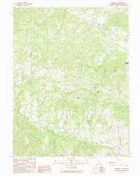
1991 Map of Yorkville
USGS Topo · Published 1991About this map
Yorkville serves as the primary node of activity in this section of Mendocino County, where the topography is defined by the complex drainage systems of Dry Creek and the Middle Fork Feliz Creek. This 1991 provisional survey documents the mountainous terrain of the California Coast Ranges, dominated by peaks such as Sanel Mtn and Snow Mtn. The landscape is scattered with remote springs, including Pregnant Spring and Hilltop Spring, which historically supported local ranching and water needs. In the northeastern corner, the map shows Duncan Springs near the prominent Duncan Peak. The intricate network of waterways like Elkhorn Creek and Ingram Creek reveals the natural corridors through which early roads and settlers navigated this winding, elevated geography.
Find a feature on this map
22 named features on this map. Tap any name to fly to it.
Don’t see what you’re looking for? This feature index may not catch every label — zoom into the map to look around manually.
Map Details
Editions of this 1991 Yorkville Map
This is the sole edition of this map. No revisions or reprints were ever made.
Other maps of this area

1920 · Ukiah
USGS Topo · 1:62,500

1938 · Hopland
USGS Topo · 1:62,500

1943 · Boonville
USGS Topo · 1:62,500

1943 · Hopland
USGS Topo · 1:62,500

1943 · Ornbaun
USGS Topo · 1:62,500

1944 · Ukiah
USGS Topo · 1:62,500

1944 · Ornbaun
USGS Topo · 1:62,500

1944 · Hopland
USGS Topo · 1:62,500

1947 · Santa Rosa
USGS Topo · 1:250,000

1949 · Santa Rosa
USGS Topo · 1:250,000