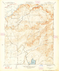
1948 Map of Yosemite Lake
USGS Topo · Published 1948About this map
Yosemite Lake anchors this Central Valley landscape, situated at the edge of the rolling foothills east of the San Joaquin Valley. The terrain is defined by a sophisticated irrigation network necessary for the region's agricultural development, featuring the Main Canal, Henderson Canal, and Lateral Canal winding through the contours. A notable piece of infrastructure, Tunnel No 1, facilitates the flow of water through the more rugged northern sections of the sheet.
Find a feature on this map
14 named features on this map. Tap any name to fly to it.
Don’t see what you’re looking for? This feature index may not catch every label — zoom into the map to look around manually.
Map Details
Editions of this 1948 Yosemite Lake Map
This is the sole edition of this map. No revisions or reprints were ever made.
Other maps of this area

1893 · Sonora
USGS Topo · 1:125,000

1896 · Sonora
USGS Topo · 1:125,000

1897 · Sonora
USGS Topo · 1:125,000

1898 · Sonora
USGS Topo · 1:125,000

1913 · Dickenson
USGS Topo · 1:31,680

1914 · Merced
USGS Topo · 1:31,680

1916 · Three Tree Flat
USGS Topo · 1:31,680

1916 · Hopeton
USGS Topo · 1:31,680

1916 · Merced Falls
USGS Topo · 1:24,000

1917 · Winton
USGS Topo · 1:31,680