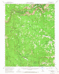
1956 Map of Yosemite
USGS Topo · Published 1968About this map
Yosemite Village serves as the focal point of human activity within this mid-century survey of the glacier-carved valley. The map documents the extensive network of early automotive routes, including the Coulterville Road and Wawona Road, which facilitated the growth of tourism and infrastructure. Evidence of early resource management and utility development appears at the Yosemite Powerhouse, while the presence of the Star Mine near the southeastern boundary reflects the region's diverse economic history before the shift toward conservation and recreation.
Find a feature on this map
106 named features on this map. Tap any name to fly to it.
Don’t see what you’re looking for? This feature index may not catch every label — zoom into the map to look around manually.
Map Details
Editions of this 1956 Yosemite Map
4 editions found
Other maps of this area

1897 · Yosemite
USGS Topo · 1:125,000

1900 · Yosemite
USGS Topo · 1:125,000

1901 · Mt. Lyell
USGS Topo · 1:125,000

1903 · Yosemite
USGS Topo · 1:125,000

1904 · Kaiser
USGS Topo · 1:125,000

1909 · Yosemite
USGS Topo · 1:125,000

1912 · Mariposa
USGS Topo · 1:125,000

1947 · El Portal
USGS Topo · 1:24,000

1947 · Mariposa
USGS Topo · 1:250,000

1947 · El Portal
USGS Topo · 1:62,500