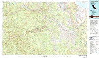
1976 Map of Yosemite Valley
USGS Topo · Published 1994About this map
Yosemite Valley and the surrounding High Sierra wilderness appear here as they were documented in the mid-1970s, reflecting a landscape defined by both its famous geological monuments and its managed backcountry. The map traces the essential corridors of the era, including Tioga Road, Wawona Road, and Big Oak Flat Road, which connect the centralized hubs of Yosemite Village and Curry Village to the park's periphery. Beyond the iconic granite faces of El Capitan, Half Dome, and Clouds Rest, the sheet reveals the complex hydrology of the region, from the Hetch Hetchy Reservoir and Lake Eleanor in the north to the Merced River canyon in the west. Small settlements like El Portal and Foresta provide a sense of the human footprint at the park boundaries, while high-altitude features like Mount Lyell and the Cathedral Range highlight the vastness of the Yosemite National Park interior.
Find a feature on this map
64 named features on this map. Tap any name to fly to it.
Don’t see what you’re looking for? This feature index may not catch every label — zoom into the map to look around manually.
Map Details
Editions of this 1976 Yosemite Valley Map
2 editions found
Other maps of this area

1891 · Big Trees
USGS Topo · 1:125,000

1893 · Sonora
USGS Topo · 1:125,000

1894 · Big Trees
USGS Topo · 1:125,000

1896 · Dardanelles
USGS Topo · 1:125,000

1896 · Sonora
USGS Topo · 1:125,000

1897 · Sonora
USGS Topo · 1:125,000

1897 · Big Trees
USGS Topo · 1:125,000

1897 · Yosemite
USGS Topo · 1:125,000

1898 · Dardanelles
USGS Topo · 1:125,000

1898 · Sonora
USGS Topo · 1:125,000