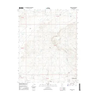
2017 Map of Youngs Lake
USGS Topo · Published 2017About this map
Farmington sits at the southern edge of this high-desert landscape, where the northern residential and industrial expansion meets the vast mesas and arroyos of San Juan County. This modern survey illustrates the complex drainage system of the Four Corners region, centered on the Youngs Lake and Locke Lake catchments. The terrain is defined by a series of prominent elevations and seasonal waterways, including the winding Narrows Wash and Cottonwood Wash. North of the city, the land rises sharply toward the Pinon Mesa and the Farmington Pinon Mesa, natural features that have historically dictated the patterns of local development and road placement. A network of rural routes, such as Twin Peaks Blvd and Indian Svc Rte 215, provides access to cattle tanks and reservoirs like Meadows Reservoir and Fourmile Reservoir, highlighting the area's continued reliance on managed water resources in an arid environment.
Find a feature on this map
46 named features on this map. Tap any name to fly to it.
Don’t see what you’re looking for? This feature index may not catch every label — zoom into the map to look around manually.
Map Details
Editions of this 2017 Youngs Lake Map
This is the sole edition of this map. No revisions or reprints were ever made.
Other maps of this area

1889 · Chaco
USGS Topo · 1:250,000

1892 · Chaco
USGS Topo · 1:250,000

1927 · Sulphur Spring
USGS Topo · 1:96,000

1928 · Kirtland
USGS Topo · 1:125,000

1932 · Kirtland
USGS Topo · 1:125,000

1954 · Shiprock
USGS Topo · 1:250,000

1958 · Shiprock
USGS Topo · 1:250,000

1959 · Shiprock
USGS Topo · 1:250,000
1963 · Farmington North
USGS Topo · 1:24,000
1963 · La Plata
USGS Topo · 1:24,000