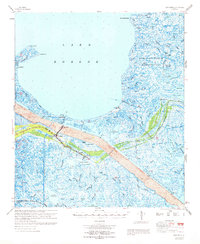
1969 Map of Yscloskey
USGS Topo · Published 1969About this map
Old Fort Beauregard Ruins stand as a historical marker along the edge of Lake Borgne, anchoring a landscape defined by the intersection of natural bayous and massive mid-century civil engineering. The dominant feature is the Mississippi River-Gulf Outlet, a deep-draft shipping channel cutting through the marshlands and flanked by extensive spoil areas. This industrial artery drastically altered the hydrology surrounding established fishing and trapping communities like Yscloskey, Alluvial City, and Shell Beach.
Find a feature on this map
70 named features on this map. Tap any name to fly to it.
Don’t see what you’re looking for? This feature index may not catch every label — zoom into the map to look around manually.
Map Details
Editions of this 1969 Yscloskey Map
This is the sole edition of this map. No revisions or reprints were ever made.
Other maps of this area

1891 · Pointe a La Hache
USGS Topo · 1:62,500

1892 · Chef Menteur
USGS Topo · 1:62,500

1892 · St. Bernard
USGS Topo · 1:62,500

1892 · Pointe a La Hache
USGS Topo · 1:62,500

1893 · Rigolets
USGS Topo · 1:62,500

1893 · La Fortuna
USGS Topo · 1:62,500

1893 · Shell Beach
USGS Topo · 1:62,500

1893 · Toulme
USGS Topo · 1:62,500

1893 · Dime
USGS Topo · 1:62,500

1895 · Bodreau
USGS Topo · 1:62,500