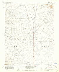
1960 Map of Yucca Flat
USGS Topo · Published 1961About this map
The Nevada Test Site dominates this 1960 topographic survey, revealing the infrastructure of early nuclear testing in the desert. Divided into numbered sectors such as Area 2, Area 4, and Area 7, the landscape is marked by unique technical indicators including several Blast Centers and sites for a Radioactive Waste Dump. The Mercury Highway serves as the primary artery through Yucca Flat, connecting functional hubs like the BJ Wye to a network of a Launching Pad, a Tower, and numerous subsurface Bunkers. This document captures the specialized geography of the Atomic Energy Commission’s operations, where topographic contour lines are interrupted by man-made Trenches and test-related Drill Hole D. Near Balloon Hill, the intersection of secret industry and desert terrain is evident through the dense placement of an Underground Telephone Line and remote infrastructure.
Find a feature on this map
25 named features on this map. Tap any name to fly to it.
Don’t see what you’re looking for? This feature index may not catch every label — zoom into the map to look around manually.
Map Details
Editions of this 1960 Yucca Flat Map
3 editions found
Other maps of this area

1907 · Las Vegas
USGS Topo · 1:250,000

1908 · Kawich
USGS Topo · 1:250,000

1908 · Furnace Creek
USGS Topo · 1:250,000

1908 · Las Vegas
USGS Topo · 1:250,000

1910 · Furnace Creek
USGS Topo · 1:250,000

1942 · Emigrant Valley
USGS Topo · 1:125,000

1942 · Indian Spring
USGS Topo · 1:125,000

1942 · Wheelbarrow Peak
USGS Topo · 1:125,000

1942 · Skull Mountain
USGS Topo · 1:125,000

1948 · Death Valley
USGS Topo · 1:250,000