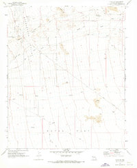
1970 Map of Yucca SE
USGS Topo · Published 1973About this map
Ground Automotive Proving grounds dominate the northwest corner of this 1970s desert landscape, reflecting the military and industrial utility of the Arizona backcountry. The terrain is defined by a series of wide, episodic drainage systems including Mackenzie Wash and Alamo Wash which cut across the alluvial fans of Dutch Flat. Resource extraction is a primary theme of the era, anchored by the presence of the Boriana Mine in the north and various prospects and drill holes scattered through the basin. Connectivity across this arid expanse is maintained by the Alamo Road and a remote Landing Strip, providing essential access for the ranching and mining operations that once operated beneath landmarks like Cactus Mtn and the isolated rise of Flattop.
Find a feature on this map
21 named features on this map. Tap any name to fly to it.
Don’t see what you’re looking for? This feature index may not catch every label — zoom into the map to look around manually.
Map Details
Editions of this 1970 Yucca SE Map
This is the sole edition of this map. No revisions or reprints were ever made.
Other maps of this area

1923 · Signal
USGS Topo · 1:250,000

1927 · Yucca
USGS Topo · 1:62,500

1927 · Buck Mountains
USGS Topo · 1:62,500

1929 · Buck Mountains
USGS Topo · 1:62,500

1929 · Yucca
USGS Topo · 1:62,500

1942 · Signal
USGS Topo · 1:250,000

1950 · Prescott
USGS Topo · 1:250,000

1954 · Needles
USGS Topo · 1:250,000

1954 · Prescott
USGS Topo · 1:250,000

1956 · Needles
USGS Topo · 1:250,000