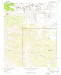
1972 Map of Yucca Valley South
USGS Topo · Published 1975About this map
Yucca Valley appears here as a growing desert community in the early 1970s, organized around the corridor of the Twentynine Palms Highway. The town's grid of residential streets, such as Joshua Drive and Golden Bee Drive, pushes up against the base of the Little San Bernardino Mountains. This high-desert landscape transition is marked by prominent landmarks like Burnt Mountain and North Park Peak.
Find a feature on this map
26 named features on this map. Tap any name to fly to it.
Don’t see what you’re looking for? This feature index may not catch every label — zoom into the map to look around manually.
Map Details
Editions of this 1972 Yucca Valley South Map
4 editions found
Other maps of this area

1901 · Southern California Sheet No. 1
USGS Topo · 1:250,000

1901 · San Jacinto
USGS Topo · 1:125,000

1902 · San Gorgonio
USGS Topo · 1:125,000

1904 · Southern California Sheet No. 1
USGS Topo · 1:250,000

1940 · Palm Springs
USGS Topo · 1:62,500

1941 · Edom
USGS Topo · 1:62,500

1944 · Palm Springs
USGS Topo · 1:62,500

1944 · Edom
USGS Topo · 1:62,500

1947 · Santa Ana
USGS Topo · 1:250,000

1949 · Santa Ana
USGS Topo · 1:250,000