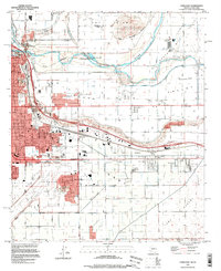
1994 Map of Yuma East
USGS Topo · Published 1998About this map
Yuma serves as the focal point of this desert landscape, positioned where the Colorado River and Gila River converge near the border with California and Mexico. The map details a complex irrigation and transport hub, where the Southern Pacific tracks and major arteries like 32d St bisect a region defined by agriculture and military aviation. Infrastructure such as the Main Canal and South Gila Canal supports the fertile South Gila Valley, contrasting sharply with the shifting sands of the Sand Dunes and the Yuma Desert.
Find a feature on this map
49 named features on this map. Tap any name to fly to it.
Don’t see what you’re looking for? This feature index may not catch every label — zoom into the map to look around manually.
Map Details
Editions of this 1994 Yuma East Map
This is the sole edition of this map. No revisions or reprints were ever made.
Other maps of this area

1903 · Yuma
USGS Topo · 1:125,000

1905 · Yuma
USGS Topo · 1:125,000

1926 · Fortuna
USGS Topo · 1:62,500

1929 · Fortuna
USGS Topo · 1:62,500

1929 · Laguna
USGS Topo · 1:62,500

1940 · Yuma
USGS Topo · 1:62,500

1942 · Yuma
USGS Topo · 1:250,000

1943 · Laguna
USGS Topo · 1:62,500

1945 · Picacho Peak
USGS Topo · 1:62,500

1945 · Yuma
USGS Topo · 1:62,500