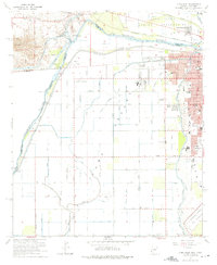
1965 Map of Yuma West
USGS Topo · Published 1975About this map
The Colorado River serves as the focal point of this mid-century survey, defining the intersection of Arizona, California, and Mexico. In the Yuma Valley, the landscape is heavily influenced by a complex irrigation network, including the Alamo Canal, California Canal, and Main Canal, which support the regional economy and the University of Arizona Agricultural Experiment Sta. The town of Yuma is shown during a period of growth, featuring established institutions like Union High Sch and the Sanguinetti Mem Park.
Find a feature on this map
52 named features on this map. Tap any name to fly to it.
Don’t see what you’re looking for? This feature index may not catch every label — zoom into the map to look around manually.
Map Details
Editions of this 1965 Yuma West Map
4 editions found
Other maps of this area

1903 · Yuma
USGS Topo · 1:125,000

1905 · Yuma
USGS Topo · 1:125,000

1940 · Yuma
USGS Topo · 1:62,500

1942 · Yuma
USGS Topo · 1:250,000

1945 · Picacho Peak
USGS Topo · 1:62,500

1945 · Yuma
USGS Topo · 1:62,500

1951 · Picacho Peak
USGS Topo · 1:62,500

1952 · Araz
USGS Topo · 1:24,000

1952 · Yuma East
USGS Topo · 1:24,000

1952 · Yuma West
USGS Topo · 1:24,000