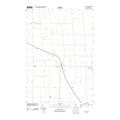
2010 Map of Zachow
USGS Topo · Published 2010About this map
Pulaski and Angelica anchor this landscape where several river systems converge, creating a complex drainage pattern defined by the Pensaukee River in the north and the Little Suamico River to the east. The terrain is crisscrossed by a dense grid of rural roads and county highways that link established small communities like Zachow, Laney, and Frazer Corners. The survey shows the modern repurposing of old corridors, such as the Mountain Bay Trl, which provides a diagonal path across the rectilinear township lines. Genealogists will find notable sites for family history research, including Resthaven Cemetery and Hillside Cemetery. Further south, Hofa Park and Black Creek mark the transition toward the agricultural heart of the region, where the East Branch Shioc River and Herman Creek drain the western reaches of the quadrangle.
Find a feature on this map
50 named features on this map. Tap any name to fly to it.
Don’t see what you’re looking for? This feature index may not catch every label — zoom into the map to look around manually.
Map Details
Editions of this 2010 Zachow Map
This is the sole edition of this map. No revisions or reprints were ever made.
Other maps of this area

1954 · Green Bay
USGS Topo · 1:62,500

1955 · Seymour
USGS Topo · 1:62,500

1955 · Green Bay
USGS Topo · 1:250,000

1956 · Gillett
USGS Topo · 1:62,500

1956 · Oconto Falls
USGS Topo · 1:62,500

1974 · Seymour
USGS Topo · 1:24,000

1974 · Cecil
USGS Topo · 1:24,000

1974 · Zachow
USGS Topo · 1:24,000
1974 · Bonduel
USGS Topo · 1:24,000
1974 · Nichols
USGS Topo · 1:24,000