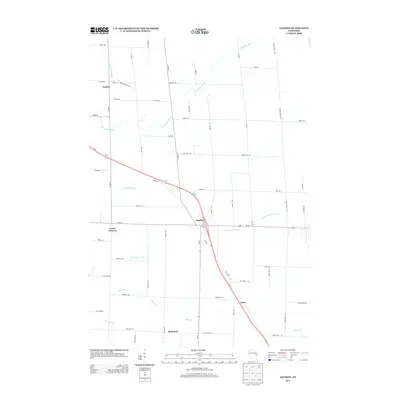
2013 Map of Zachow
USGS Topo · Published 2013About this map
Zachow and Angelica serve as primary hubs in this agricultural landscape of eastern Wisconsin, where a network of rural roads connects several small crossroads communities. This 2013 survey illustrates the drainage patterns of the region, featuring the Pensaukee River in the north and the Little Suamico River passing through Angelica. The diagonal corridor of Wi-29 bisects the area, providing a modern contrast to the established grid of family-named routes such as Cedar Rd, Apple Rd, and Maple Rd. Local historians can trace the proximity of traditional settlements like Frazer Corners, Laney, and Hofa Park, each situated near the headwaters of various creeks including Black Cr and Herman Cr. The presence of the Mountain Bay Trl following an old rail corridor through Zachow highlights the transition of the region's transport infrastructure from industrial rail to modern recreational use.
Find a feature on this map
57 named features on this map. Tap any name to fly to it.
Don’t see what you’re looking for? This feature index may not catch every label — zoom into the map to look around manually.
Map Details
Editions of this 2013 Zachow Map
This is the sole edition of this map. No revisions or reprints were ever made.
Other maps of this area

1954 · Green Bay
USGS Topo · 1:62,500

1955 · Seymour
USGS Topo · 1:62,500

1955 · Green Bay
USGS Topo · 1:250,000

1956 · Gillett
USGS Topo · 1:62,500

1956 · Oconto Falls
USGS Topo · 1:62,500

1974 · Seymour
USGS Topo · 1:24,000

1974 · Cecil
USGS Topo · 1:24,000

1974 · Zachow
USGS Topo · 1:24,000
1974 · Bonduel
USGS Topo · 1:24,000
1974 · Nichols
USGS Topo · 1:24,000